Used Leica RTC360 Cyclone Field 360
Used Leica RTC360 Cyclone Field 360, almost new, 1 year Leica warranty, Low Hours, CCP Silver Cyclone FIELD 360
Used 3D Scanners
Leica Geosystem
Leica RTC360 3D Scanner Cyclone Field 360, 1 Year Leica warranty, like new, low hours used. The 1 Year Leica warranty includes Customer Support Extended Warranty and Hardware Maintenance and Calibration
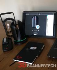
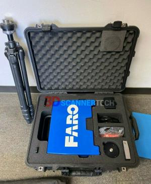
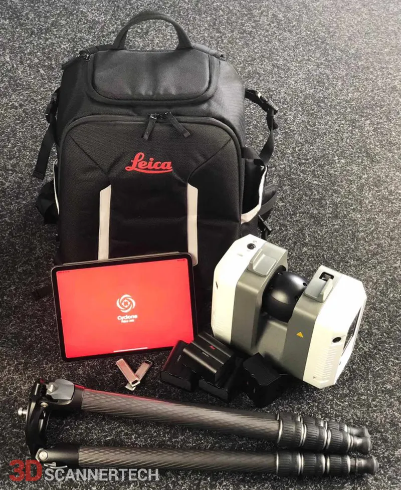
Leica RTC360 for sale includes:
- Leica RTC360 Laser Scanner (1 Year RTC360 Laser Scanner CCP Silver)
- Tablet iPad Pro 12.9 inch 512GB with Leica Cyclone FIELD 360 Software installed
- 4x GEB361 Lithium-Ion Battery
- 1x GKL341 Multicharger Prof 5000
- 2x RTC360 USB Flash Drive 256 GB
- 1x RTC360 Transport Container
- RTC360 System USB Card
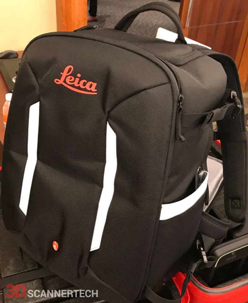
- RTC360 Backpack
- Carbon Tripod
- 1 year RTC360 CCP Silver contract
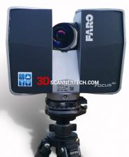
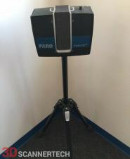
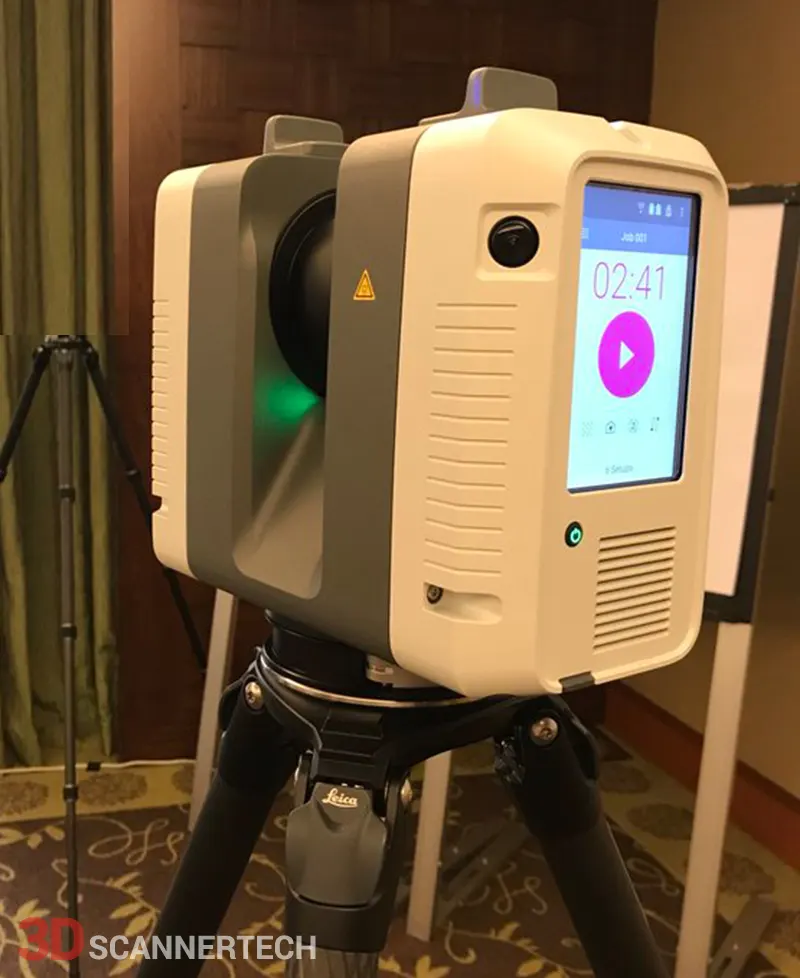
LEICA RTC360 3D LASER SCANNER
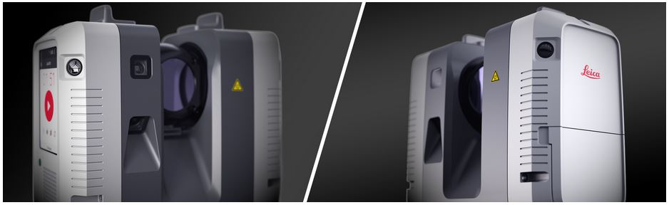
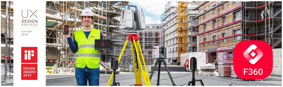
Automatically pre-register point cloud data in the field to quickly conduct quality control checks, improve productivity and make better-informed decisions on site. The Leica RTC360 3D reality capture solution empowers users to document and capture their environments in 3D, improving efficiency and productivity in the field and in the office through fast, simple-to-use, accurate, and portable hardware and software. The RTC360 3D laser scanner is the solution for professionals to manage project complexities with accurate and reliable 3D representations and discover the possibilities of any site.
- Highly portable, highly automated, intuitive and designed for maximum productivity, the RTC360 solution efficiently combines the RTC360 a high-performance 3D laser scanner, Leica Cyclone FIELD 360 mobilde-device app for edge computing for automatically registering scans in real time, and Leica Cyclone REGISTER 360 office software to integrate your 3D model seamlessly into your workflow
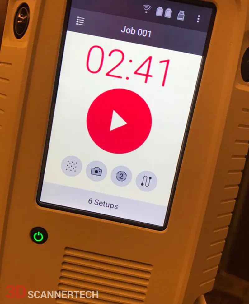
- Capture scans, including enriching High-Dynamic Range (HDR) imagery, in less than two minutes.
- Automatically record your moves from station to station to pre-register your scans in the field without manual intervention.
- Augment your data capture with information tags illustrating the opportunities for better planning, reflect site reality, and boost your teams’ situational awareness.
- Directly publish your captured data from Cyclone FIELD 360 to Leica TruView Cloud to quickly exchange project information prior to import and registration.
Fast: The new Leica RTC360 laser scanner makes 3D reality capture faster than ever before. With a measuring rate of up to 2 million points per second and advanced HDR imaging system, the creation of coloured 3D point clouds can be completed in under two minutes. Plus, automated targetless field registration (based on VIS technology) and the seamless, automated transfer of data from site to office reduce time spent in the field and further maximise productivity.
Agile: Small and lightweight, the Leica RTC360 scanner’s portable design and collapsible tripod mean it’s compact enough to fit into most backpacks, ready to be taken anywhere. Once on-site, easy-to-use, one-button operation makes for fast, hassle-free scanning.
Precise: Low noise data allows for better images, resulting in crisp, high-quality scans that are rich in detail and ready for use in a range of applications. Combined with Cyclone FIELD 360 software for automated registration in the field, the Leica RTC360 scanner offers outstanding precision that can be checked on-site.
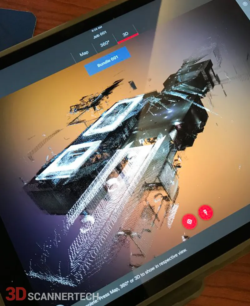
Pre-registraton in the field: As part of the RTC360 solution, the Cyclone FIELD 360 app links the 3D data acquisition in the field with the laser scanner and data registration in the office with Cyclone REGISTER 360. On-site the user can automatically capture, register and examine scan and image data. The user interface combines easy handling of complex calculations with a graphical user guidance that offers a remarkable user experience, also for novice users
Cyclone FIELD 360
The high-performance Leica Cyclone FIELD 360 mobile-device app is the perfect field companion for the Leica RTC360 3D laser scanner. With its intuitive user interface, remote scanner control and on-site point cloud display, navigation is a breeze - even for novice users – with full imagery and point cloud data delivered directly to the tablet using edge computing technology.
RTC360 data captured in the field is also immediately available in multiple software applications, serving field tags, assets, HDR imagery and 3D point cloud in JetStream powered solutions. In conjunction with the release of the RTC360 solution, a full release of the Cyclone product family is scheduled together with hardware shipments.
|
|
|
| GENERAL | |
| 3D Laser Scanner | High-speed 3D laser scanner with integrated HDR spherical imaging system and Visual Inertial System (VIS) for real time registration |
| PERFORMANCE | |
| Data acquisition | <2 mins for complete full dome scan and spherical HDR image at 6mm @ 10 m resolution |
| Real time registration | Automatic point cloud alignment based on real time tracking of scanner movement between setups based on Visual Inertial System (VIS) by video- enhanced inertial measurement unit |
| Double scan | Automatic removal of moving objects |
| SCANNING | |
| Distance measurement | High-speed, high dynamic time of flight enhanced by Waveform Digitising (WFD) technology |
| Laser class | 1 (in accordance with IEC 60825-1:2014), 1550 nm (invisible) |
| Field of view | 360° (horizontal) / 300° (vertical) |
| Range | Min. 0.5 - up to 130 m |
| Speed | Up to 2,000,000 pts / sec |
| Resolution | 3 user selectable settings (3/6/12 mm @ 10 m) |
| Accuracy | Angular accuracy 18” Range accuracy 1.0 mm + 10 ppm 3D point accuracy 1.9 mm @ 10 m 2.9 mm @ 20 m 5.3 mm @ 40 m |
| Range noise | 0.4 mm @ 10 m, 0.5 mm @ 20 m |
| IMAGING | |
| Camera | 6 MP 3-camera system captures 432 MPx raw data for calibrated 360° x 300° spherical image |
| Speed | 1 minute for full spherical HDR image at any light condition |
| HDR | Automatic, 5 brackets |
| NAVIGATION SENSORS | |
| Visual Inertial System | Video enhanced inertial measuring system to track movement of the scanner position relative to the previous setup in real time |
| Tilt | IMU based, Accuracy: 3‘ for any tilt |
| dditional sensors | Altimeter, Compass, GNSS |
| OPERATION | |
| On scanner | Touch-screen control with finger touch, full colour WVGA graphic display 480 x 800 pixels |
| Mobile devices | Leica Cyclone FIELD 360 app for iPad or Android tablets including: - Remote control of scan functions - 2D & 3D data viewing - Tagging - Automatic alignment of scans |
| Wireless | Integrated wireless LAN (802.11 b/g/n) |
| Data storage | Leica MS256, 256 GB exchangeable USB 3.0 flash drive |
| DESIGN & PHYSICAL | |
| Housing | Aluminium frame and sidecovers |
| Dimensions | 120 mm x 240 mm x 230 mm / 4.7‘‘ x 9.4‘‘ x 9.1‘‘ |
| Weight | 5.35 kg / 11.7 lbs, nominal (without batteries) |
| Mounting mechanism | Quick mounting on 5/8“ stub on lightweight tripod / optional tribrach adapter / survey tribrach adapter available |
| POWER | |
| Internal battery | 2 x Leica GEB361 internal, rechargeable Li-Ion batteries. Duration: Typically up to 4 hours Weight: 340 g per battery |
| External | Leica GEV282 AC adapter |
| ENVIRONMENTAL | |
| Operating temperature | -5° to +40°C |
| Storage temperature | -40° to +70°C |
| Dust/Humidity | Solid particle/liquid ingress protection IP54 (IEC 60529) |
LEICA CYCLONE FIELD 360 | Automatically pre-register and align scans directly in the field
As part of the Leica Geosystems 3D Reality Capture Solution, the Leica Cyclone FIELD 360 mobile-device app links the 3D data acquisition directly in the field with the Leica RTC360 laser scanner, Leica ScanStation P30 , Leica ScanStation P40 and P50 survey-grade laser scanners, or BLK360 imaging laser scanner and the final data registration with Leica Cyclone REGISTER 360 post-processing office software.
On-site the user can automatically capture, register and examine scan and image data. The user interface combines easy handling of complex calculations with a graphical user guidance which offers a remarkable user experience also for novice users. With Cyclone FIELD 360 Quick Plan, you can create floor plans for a simple set of rooms directly in the field.
Unleash the full potential of LiDAR sensor-enabled Apple devices with Cyclone FIELD 360. Take advantage of Apple's built-in LiDAR sensor to collect scan data or fill gaps in existing point clouds with 3D tags.
View: The high-performance Leica Cyclone FIELD 360 mobile-device app is the perfect field companion for the RTC360 3D laser scanner, the ScanStation P30/P40 and P50, as well as the BLK360 imaging laser scanner. With its intuitive user interface, remote scanner control and on-site point cloud display, navigation is a breeze - even for novice users – with full imagery and point cloud data delivered directly to a tablet using edge computing technology.
Check: Direct data access and visualisation are the foundation for quality control in the field; with Cyclone FIELD 360, automatically pre-registered point cloud data enables users to quickly conduct on-site quality control checks, improves productivity and makes for better-informed decisions in the field. Furthermore, directly publish your captured data from Cyclone FIELD 360 to Leica TruView Cloud or HxDR to quickly exchange project information prior to import and registration.
Add: For improved interpretation in Leica Cyclone REGISTER 360 post-processing, and to add extra value and information to 3D data, Cyclone FIELD 360 enables on-site tagging of measurements, videos, images, text or voice files to the point cloud geometry simply by using a tablet or smartphone.
- Download Leica RTC360 Datasheet.pdf
- Download Leica RTC360 Equipment List.pdf
- Download Leica Cyclone FIELD 360 Datasheet.pdf